Drift Falls
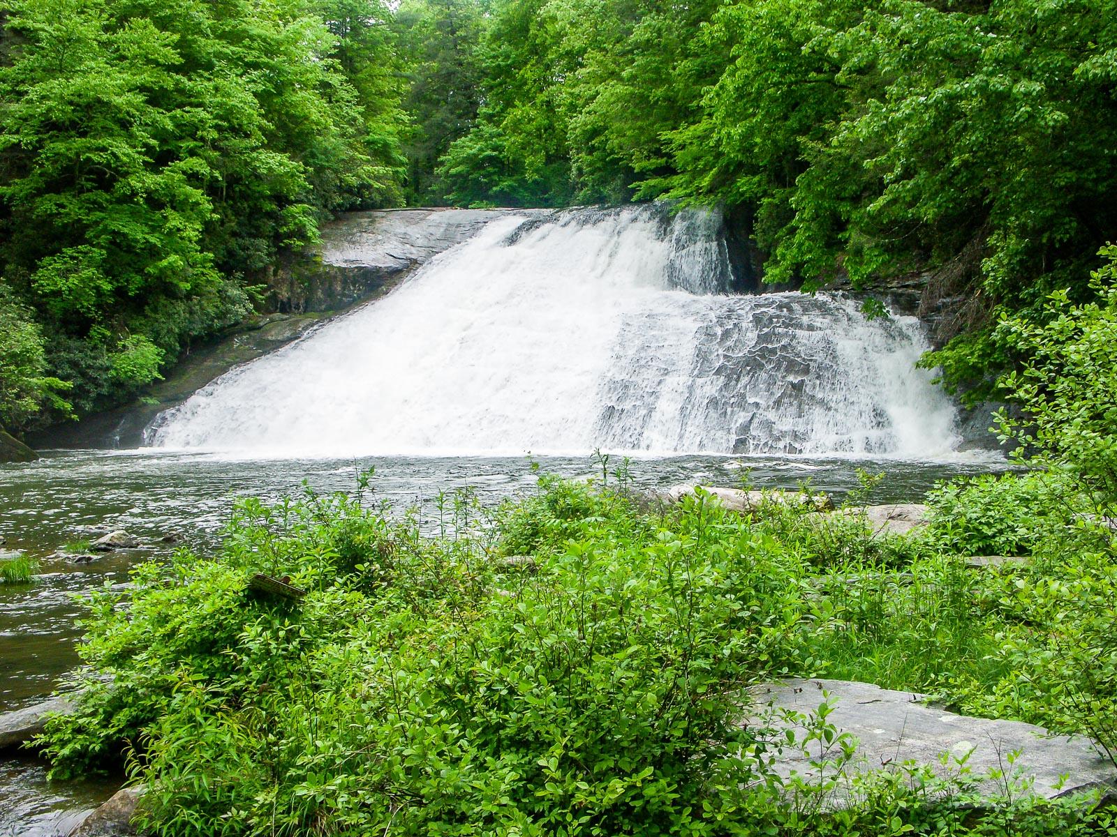
Drift Falls is a neat sliding cascade which drops into a huge, deep pool. The far right side (facing upriver) drops into a hole of some sort and the falls gets much wider on its lower half. It has a fairly high water volume. It's a shallow incline - so shallow, in fact, that people have been known to slide down the falls, giving it its alternate name - Bust your Butt Falls. However, the current landowner strictly forbids access beyond the viewing area for the falls.
Statistics
- Height: 30
- Elevation: 2800 ft
- Stream: Horsepasture River
- Landowner: Private (LBM Industries Inc.)
- GPS: 35.093523, -82.969262
Hike Information
- Difficulty: More Difficult
- Length: 4.0mi
- Tread Condition: Moderately Rough
- Climbing: Hilly (850 ft)
Map
GPS Directions & Map
From Current Location or address:
Driving Directions
From downtown Brevard, it is just over 18 miles on US 64 West to the intersection with NC Hwy 281 South - turn left. From Highlands, it's just over 20 miles on US 64 East, thru Cashiers, to NC 281 South - turn right. Go 0.9 miles South on NC 281 from US 64 to the park entrance road on the left. It's a little over a mile straight on the main road to the parking area for the Rainbow Falls trail. Park there.
Trail Description

Start the hike on the trail leading away from the sign boards. The first section of trail you will hike has a gravel surface. It leads gently uphill at first, but very soon begins descending. From the very beginning, you can hear the roar of the Horsepasture River in the valley far below, which you'll reach in about 1 mile. The trail winds downhill through a ridge-top forest and intersects an old roadbed just after a hairpin turn. Bear right to continue on the trail.
The old roadbed continues downhill as well, and its surface has also been graveled. It resembles more of an ATV track than a trail at this point. The roar of the river grows louder before fading completely as you dip into a side cove. You'll notice the trail getting a bit steeper before it crosses a small stream. Just past this crossing, the trail passes off of Gorges State Park property and onto National Forest property. It's still called the Rainbow Falls trail (#499).
Once it it crosses onto the National Forest - and into the Horsepasture Wild and Scenic River corridor - the trail is no longer gravel-surfaced and blazed; however, it is easy to follow. It's the same old road bed you were on before anyhow. The trail descends a bit more steeply to another, larger creek crossing. You'll get your feet wet on this one if the water is up.
At this point you're near the river. Some narrower paths thread through the woods on the left just before the creek - that is the trail to Stairway Falls, which is not officially part of this hike. Make note of it, so that on the way back you can visit if you'd like.
Just past the creek, the trail winds up in a large, flat campsite. Follow the trail through the campsite and out the other side, which will take you to within a few feet of the river. The trail begins following the river uphill on the right side, where it gets a bit rougher and steeper. At times, the trail is very close to the river; at other times, it climbs uphill a bit further away. One spot climbs up over a rock outcrop which gives you a neat view down on the river from above.

There are several cascades along this stretch of river, interspersed by deep pools - but nothing like what lies just upstream. The trail will begin a more significant climb before long and that's when you know you're getting close to Rainbow Falls. About 1/2 mile past the campsite, the trail curves right, into an open area created by mist from the raging cascade. That's where you get your first view of the falls, from behind a fence along the trail.
This frontal view of the falls is the best place to see the rainbows in the mist that give the falls its name. They're primarily visible in the morning, when the sun is low. They're also notoriously difficult to photograph, since when the sun is shining, the light is not always the best - and the mist threatens to soak your lens and ruin your camera. The opening is thought to be kept open naturally by the constant spray mist and wind from the falls. During floods, the wind coming up the slope here is almost enough to knock you off your feet!
The trail goes through the mist zone and goes back into the forest on the other side of the opening. Another path splits left just before the trail goes into the forest. This little spur runs close to the base of the falls on the right side, to a neat view from beside the cliff. Other scramble paths lead to the rocks in front of the falls, but if you choose to go that way, be extremely careful. The strong sun and constant mist make all the mud, grass, and rocks all get covered by an impossibly slippery slime. You'll get soaked, too.
You can return to your vehicle from here to make this a 3-mile round trip hike as officially advertised by the State Park. However, the trail - and optionally, the hike - continues about a half mile further upstream to a couple of smaller cascades and waterfalls - namely, Turtleback Falls and the one we're after - Drift Falls.
The trail climbs steeply as it winds up and around toward the top of Rainbow Falls. It's eroded in places, with steep side slopes eating into the trail surface. Use caution. The trail comes out at a point near the top of the falls. Many people go out onto the rocks near the brink, and it is a neat view. However, people have also died by falling from up here. Recently. Choose your actions wisely.

The trail continues safely upstream, passing some nice churning cascades, and reaches Turtleback Falls in about 0.2 miles. A little side path leads to a boulder with a great front view of the rounded falls, which ends in a deep, churning pool. This is a popular sliding, swimming, and jumping spot. But you've seen what's just downstream, and people have been swept from here over the brink of Rainbow Falls. Recently. Again - choose wisely.
It's about another 1/4 mile to Drift Falls from here. The trail continues around Turtleback Falls, crossing a small trickling tributary, and then comes out on the rocks above the main drop. Then it continues upstream, going back into the woods. You'll reach a junction - the rocky trail to the right, going steeply uphill, used to lead to NC 281. That trail is now closed. So bear left, continuing to follow the river.

The trail winds through a flat area, crosses over a small tributary stream, and ends abruptly at a huge sign at the private property boundary. Go left, down a small scramble path onto the river rocks, to get a view of Drift Falls across its plunge pool. But be sure to stay back from the private property line. (There are plenty of signs to remind you). Thankfully, there is plenty of room to view the falls from National Forest property.
When you've seen enough, return to your vehicle on the same path.